


![]()
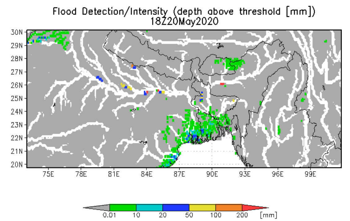
"Cyclone Amphan is expected to make landfall in India on 20 May, on the coasts of India and Bangladesh between the Sagar Islands in West Bengal and the Hatiya Islands in Bangladesh. The storm is currently Category Four on the Saffir-Simpson scale, but when it entered the Bay of Bengal on 18 May it was the strongest storm on record in the area and classified as a Super Cyclone. The storm had wind speeds of 270 kilometres per hour, but has since weakened to 200 kilometres per hour. The strong winds are expected to cause damage and the storm is forecast to bring heavy rain causing flooding. Storm surges of up to 4 metres are expected in some areas. Officials are working to evacuate people in the affected areas (estimated to be as many as 300,000) but are finding it difficult to relocate the evacuees. Due to the Coronavirus, many in the country are under lockdown, and space in emergency shelters is limited due to distancing measures. While the shelters would normally accommodate as many as 500,000, they now may only have capacity for half that number." Quoted from International Charter Space and Major Disasters .
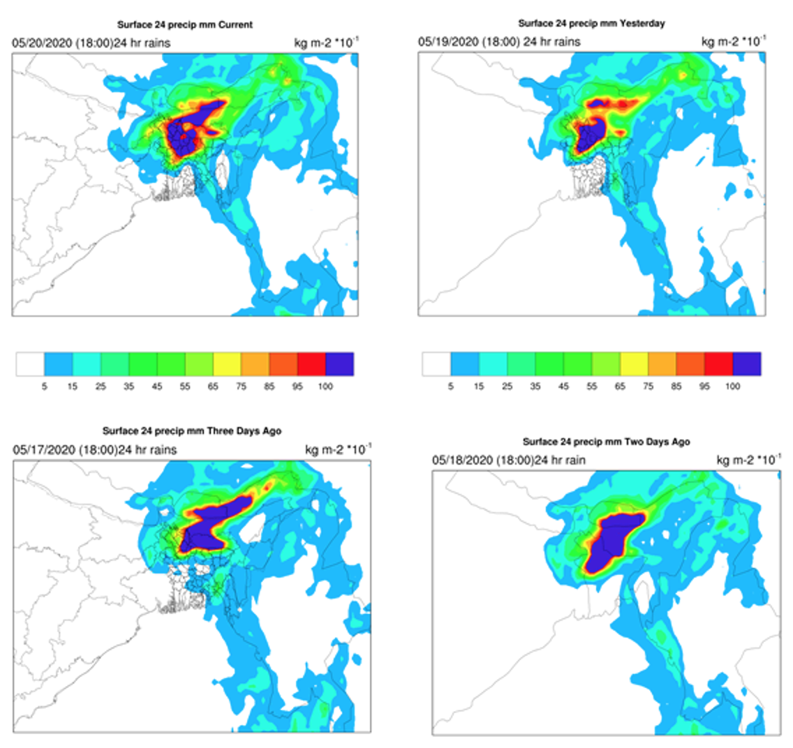
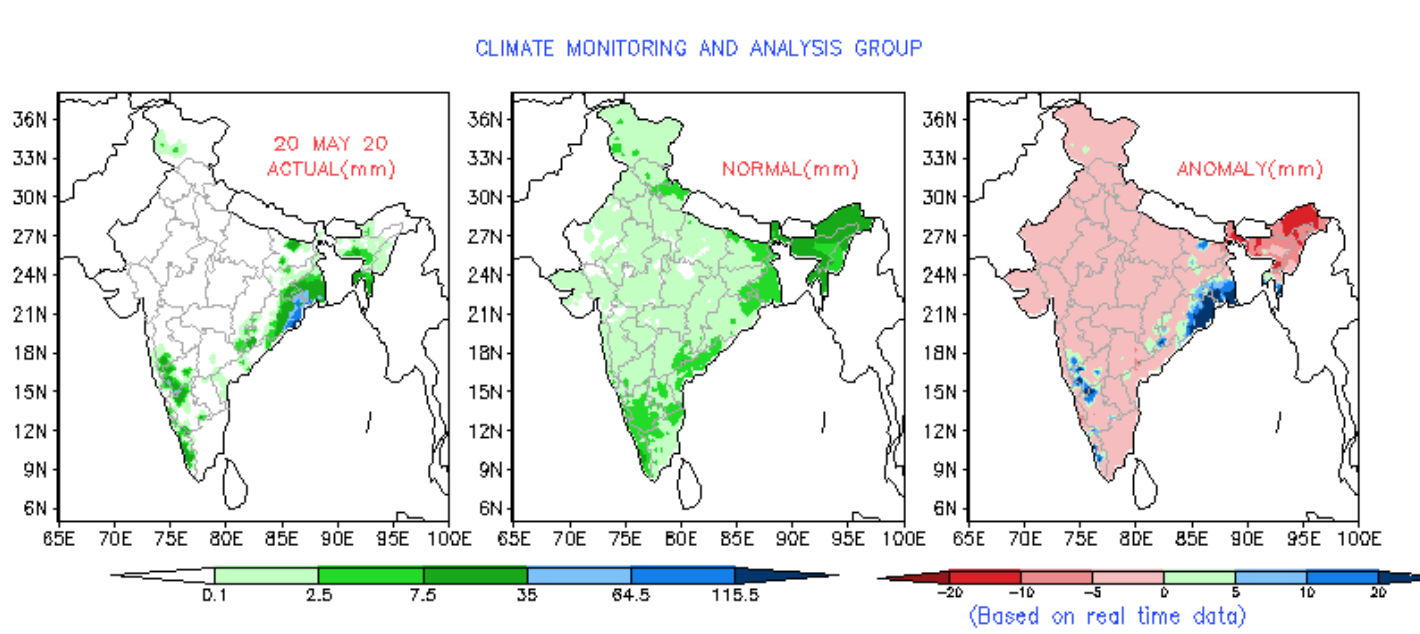
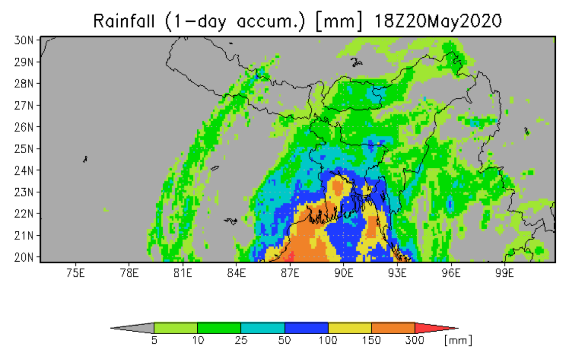
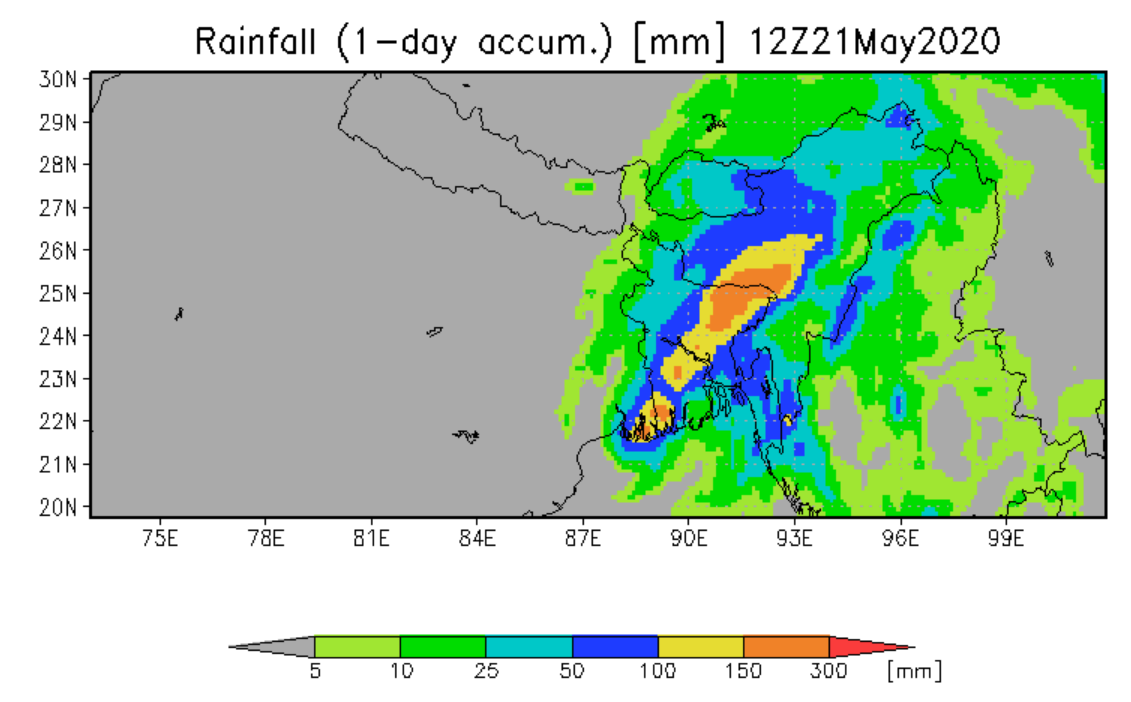
India and Bangladesh – Torrential Rain From Cyclone Amphan Triggers Flooding 21 May, 2020 by FloodList News in Asia. "Storm surge and torrential rain brought by Cyclone Amphan caused flooding in parts of West Bengal in India and Bangladesh. Amphan made landfall in eastern India on 20 May, with winds of 185 km/h causing damage in the state of Odisha and in particular in West Bengal in India before moving on to Bangladesh. Thousands of homes have been damaged or destroyed. Winds ripped off roofs and downed trees and power lines. Millions across India and Bangladesh have been left without electricity. West Bengal Chief Minister Mamata Banerjee said at least 12 people had died in the state. The Chief Minister said the districts of South and North 24 Parganas and East Midnapore were the worst affected. At least 9 people are thought to have died in Bangladesh with fatalities reported in the districts of Jashore, Bhola, Barguna, Patuakhali and Pirojpur. More than 650,000 people had preemptively evacuated their homes in West Bengal and Odisha states in India. As many as 2.4 million people had moved to safe shelters in Bangladesh. Amphan dumped more than 250 mm of rain in 24 hours in Kolkata, flooding the city’s streets. Images on Social Media showed flood water up to car windows. Kolkata Airport was also flooded and flights temporarily suspended. Heavy rain was also reported in parts of Bangladesh. Ishwardi in the west of the country recorded over 155mm of rain in 24 hours to 21 May. Storm surge of 1.5 metres was reported along parts of the country’s low-lying coast. An embankment in Bagerhat District in Khulna Division collapsed, flooding nearby villages." Quoted from FloodList .
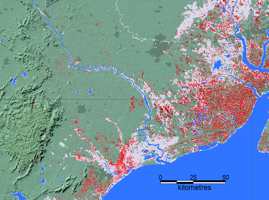
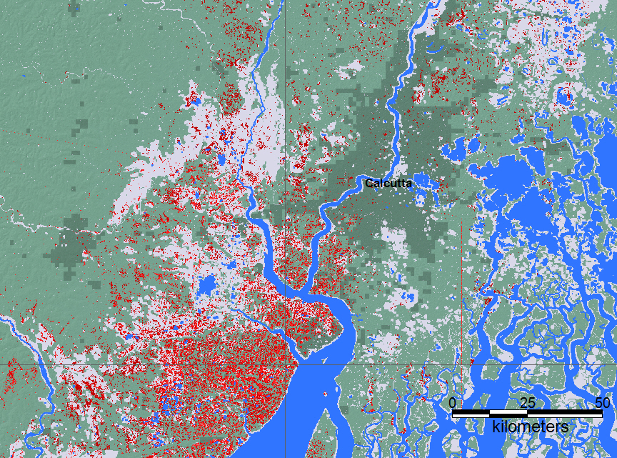
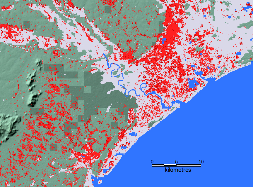
The Flood Observatory maintains a Global Active Archive of large flood events, 1985 to present. New major flood events are entered into this archive each week. A hand-drawn GIS polygon for each event outlines the region affected.
This event was selected for Observatory production of map and GIS data products.This web page and associated image and map (GIS) files become the permanent Flood Observatory record of the flood.
As part of collaborations with other organizations, including
GEO and the Global Flood
Partnership, the Observatory's maps are made available here to the public.
Geotif versions and GIS files are also available. With attribution, maps and
data can be used freely for non-commercial purposes. With permission, they can
be used for commercial purposes. Consult the Creative Commons Attribution-NonCommercial-ShareAlike 4.0
International License and Robert.Brakenridge or Albert.Kettner (at
Colorado.edu) if questions. Attribution for this map when Sentinel SAR data are
used: "Dartmouth Flood Observatory at the University of Colorado, from satellite
data provided by NASA and Copernicus/European Space Agency". When using GIS data
(see below) provided to DFO from other sources, please acknowledge original
source.
NASA Landsat 8 and Copernicus/ESA Sentinel SAR data if used in this map were obtained from the the U.S. Geological Survey Hazards Data Distribution System. and the Sentinels Science Data hub, respectively. Landsat 8 is jointly managed by NASA and the United States Geological Survey. Copernicus is supported by the European Commission. MODIS data are obtained from the NASA NRT Global Flood Mapping facility (surface water extents) and from NASA Worldview (image files); SUOMI/VIIRS image data are also retrieved from NASA Worldview.
Flood extent files (Shp or Mapinfo) supporting this Flood Event Map are located here.
These files may include high spatial resolution mapping such as from Sentinel or Landsat, or lower resolution files from MODIS. File names commonly include the sensor source (e.g., S1 for Sentinel 1, LS8 for Landsat, MODIS, Aqua, or Terra for MODIS), the image date, and if from a non-DFO souce, a source identifier (for this event. "EOS_Aria" file names include "final_merged"). EOS-Aria Shp files are retrieved from Earth Observatory of Singapore).
The NASA Earth Sciences Program, the Latin American Development Bank, the World Bank, the European Commission's Global Disaster Alert and Coordination System, GDACS, and Copernicus Emergency Management Service, the Google Earth Engine research awards program, the Committee on Earth Observation Satellites (CEOS) Disasters Working Group-Flood Pilot, the Japanese Space Agency, and the European Space Agency all have supported the Observatory's work via research grants and contracts or free satellite-derived data.
The Dartmouth Flood Observatory was founded by Robert Brakenridge in 1993 at Dartmouth College, Hanover, NH USA and moved to the University of Colorado, INSTAAR, CSDMS in 2010. The institutional support of both universities is gratefully acknowledged.
(counting since May 20, 2020)