|
|
|
|
|
|
|
|
|
|
|
|
|
|
|
|
|
|
|
|
|
|
|
Prof. G. Robert Brakenridge |
|
|
|
Senior Research Scientist |
|
| To access
individual site data: proceed to regional displays, below. |
|
|
CSDMS, INSTAAR, University of Colorado |
|
| Discontinued
October 4, 2011. |
|
|
Campus Box 450 |
|
| Please proceed to River Watch Version 2 |
|
|
Boulder, CO 80309-0450 USA |
|
|
|
River Watch Version 1 (discontinued) |
|
|
| Data for: |
8-Sep-11 |
|
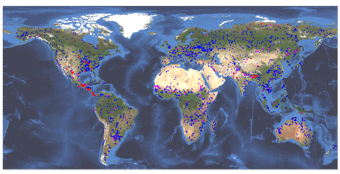
Yellow: low flow or ice-covered |
|
Technical Summary |
|
|
Blue: normal |
|
|
|
|
Purple: flood |
|
Crosses (red and yellow): from gaging station data |
Satellite Gauging Site Locations |
|
|
Red: major flood |
|
|
| This display uses
NASA/JAXA AMSR-E data (Ashcroft, P., and Wentz, F., 2006, updated daily, AMSR-E/Aqua L2A Global Swath Spatially-Resampled Brightness
Temperatures V002, Boulder, Colorado USA,
National Snow and Ice Data Center) |
|
| to estimate river
discharge at over 2500 selected river measurement sites. |
|
| In 2009, we are
testing and calibrating the several thousand river measurement points in this
display. |
|
|
|
|
|
|
|
|
|
|
|
|
|
|
|
|
|
|
|
|
|
|
|
|
|
|
|
|
|
|
|
|
|
|
|
|
|
|
|
|
|
|
|
|
|
|
|
|
|
|
| Sample Results |
Recent AGU presentation |
|
|
|
| Regional Displays |
(To access estimated discharge results, click on
dots in regional displays) |
|
|
|
| Central
America |
|
| Alaska |
|
|
|
| Western
North America |
|
|
|
| Western
Canada |
|
|
| Eastern
North America |
|
|
| Northern
South America |
|
|
| Southern
South America |
|
River Watch is a cooperative
project between the Dartmouth Flood Observatory, Dartmouth College, Hanover
NH USA |
|
| Europe |
|
and |
|
| Eastern
Europe |
|
GDACS-GFDS (Global Disaster
Alert Coordination System, Global Flood Detection System), European
Commission Joint Research Centre, Ispra, Italy |
| Western
Africa |
|
| Northeastern Africa |
|
The Flood Observatory is supported in part by grants
from NASA |
|
| Southern Africa |
|
| Indian
Subcontinent |
|
G. R. Brakenridge, University of Colorado |
|
| Western
Asia |
|
S.V. Nghiem, Jet Propulsion Laboratory |
|
| Eastern
Asia |
|
Co-Investigators: |
T. De Groeve, JRC |
|
| Southeastern
Asia |
|
Z. Kugler, JRC |
|
| Australia
Region |
|
|
| Return To River Watch Home |
|
Some relevant publications: |
2007 Water Resources Research article |
|
|
Copyright 2007 American Geophysical Union. Further
reproduction or electronic distribution is not permitted. |
|
|
|
2005 EOS article |
|
|
|
|
Copyright 2005 American Geophysical Union. Further
reproduction or electronic distribution is not permitted. |
|
|
|
2008 JRC GDACS Report |
|
|
|
|
|
|
|
|
|
|
|
|
|
|
|
|
|
|
|
|
|
|