| 02/27/00 | 02/28/00 | 02/29/00 | 03/01/00 | 03/02/00 | 03/03/00 | 03/04/00 |
 |
 |
 |
 |
 |
 |
 |
| 03/05/00 | 03/06/00 | 03/07/00 | 03/08/00 | 03/09/00 | 03/10/00 | 03/11/00 |
 |
 |
 |
 |
 |
 |
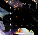 |
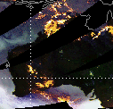
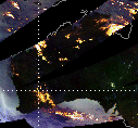
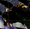
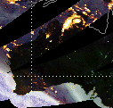
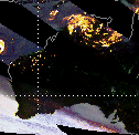
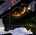
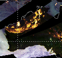
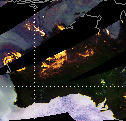
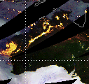
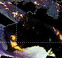
TRMM TMI Quick Look Images, subsetted at Dartmouth from global mosaics prepared by Chris Kidd, NASA-Goddard Space Flight Center
Comments:
Tropical Cyclone Steve swept in a counter clockwise arc around the Australian continent, first hitting ground at Cairns on the northern coast of Queensland late on February 27 (March 6, 2000, Associated Press wire report; see TRMM report for DFO-2000-6 at http://www.dartmouth.edu/artsci/geog/floods/00006.html). The storm degenerated into a tropical low as it moved overland but regained strength, reforming as a cyclone, as it continued east over the Gulf of Carpentaria (March 6, 2000, Associated Press wire report). Steve crossed more than 2,000 km of Australia's northern coast, forming three times and dying twice over a ten day period, an unprecedented occurrence according to weather forcasters (March 7 report, AAP Information Services Pty. Ltd.). On March 7 after reaching the west coast, the cyclone headed south, finally leaving the country at the southern coast of Western Australia on March 11.
TRMM TMI data below show Tropical Cyclone Steve moving from Queensland over the Gulf of Carpentaria during February 27 - 29 and proceeding over Northern Territories during the first three days in March. According to a weather bureau spokesman, the top of Northern Territory received 80 mm of rain in 24 hours on March 3 (March 4, 2000, AAP Information Services Pty. Ltd.). Another area received more than 200 mm of rain. Weather was clearing by March 4 as Steve moved on towards Western Australia. By late March 5, the cyclone was pounding the northwest coast with high winds and flood producing rains. By the evening of March 6 Steve, now a category 2 cyclone, "was 50 kilometres north-west of Karratha and 195 kilometres north-east of Onslow, and moving west-south-west at 18kph . It had been almost stationary for two hours." (March 6 report, AAP Information Services Pty. Ltd.). Forecasters predicted the storm would intensify to category 3 overnight (March 6 report, AAP Information Services Pty. Ltd.), but instead it weakend to a category 1 storm after moving inland (March 6, 2000, Associated Press wire report). According to the Bureau of Meteorology, the eye of the storm crossed the Western Australia coast early on March 7 between the outback towns of Mardie and Onslow, before heading slightly southwest and inland with windspeeds of up to 110 kmp. Heavy rain continued to fall and wind gusts dropped from 93 mph (150 kph) to 56 mph (90 kph) (March 6, 2000, Associated Press wire report). Heavy rain was anticipated to continue causing widespread flooding throughout the Pilbara and northern Gascoyne regions of Western Australia.
Dates for wire reports are local and not necessarily the same as in Australia at that same time.
In these images:
Rainfall and snowfall: yellow and white areas (yellowish white is highest intensity precipitation)
Oceans: light blue (low water vapour) to dark blue (high water vapour)
More information: http://trmm.gsfc.nasa.gov/data/quicklook/quick_looks.html
| 02/27/00 | 02/28/00 | 02/29/00 | 03/01/00 | 03/02/00 | 03/03/00 | 03/04/00 |
| |
|
|
|
|
|
|
| 03/05/00 | 03/06/00 | 03/07/00 | 03/08/00 | 03/09/00 | 03/10/00 | 03/11/00 |
| |
|
|
|
|
|
|