Flood Hydroclimatological Analysis
DFO 2000-6
Flooding: 02/18/00-02/29/00
Inland Queensland, Northern New South
Wales and North-west South Australia in Australia
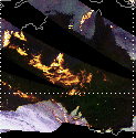
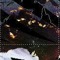
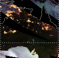
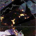
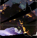
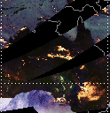
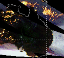
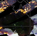
(1) 21 Day Precipitation History
TRMM TMI Quick Look Images, subsetted at Dartmouth
from global mosaics prepared by Chris Kidd, NASA-Goddard Space
Flight Center
Comments:
TRMM TMI data show heavy rain over the states
of South Australia and New South Wales on February 9-12. The northwest
part of South Australia experienced flooding begining on February
11 after receiving over 15cm of rain in two days. Flooding was
also reported in the adjacent Northern Territory in the Ayers
Rock area along the Finke, Hugh and Palmer rivers.
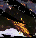
Starting on February 13 smaller areas of heavy
rain can be seen over various parts of Queensland including the
Great Dividing Range, York Peninsula and the coastal area near
the Great Barrier Reef. Flooding was first reported in coastal
Queensland in the town of Giru along the Haughton River on February
18; the next day there were submerged train lines near nearby
Townsville. The runoff from much of this precipitation flows into
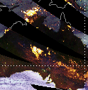
the Great Artesian Basin in central inland Queensland. On February
17-19 and the 22nd TRMM TMI data show heavy rain directly over
the main area of flooding in Queensland; this area was bounded
by the towns of Richmond, Hughenden, Muttaburra, Longreach and
Winton. On February 23 there were reports that flooding of the
Diamantina River had totally isolated the town of Winton; farther
east along the Thomson River, over 60 people were evacuated in
the town of Longreach.
By February 24 a third of the state of Queensland
was under water, the water forming a giant lake over the Queensland
channel country. Flooding also continued in the Northern Territory
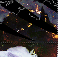
and spread into New South Wales state.On February 26 Cyclone Steve
can be seen approaching the coastal city of Cairns in the TRMM
TMI data On the 27th it came ashore in northern Queensland and
caused more flooding along the coast. Residents of the town of
Mareeba had to be evacuated when the Barron River burst its banks.
The water from Queensland moved downriver in to New South Wales
where the Broken Hill area was flooded by the Paroo River on February
28.
In these images:
Rainfall and snowfall: yellow and white areas
(yellowish white is highest intensity precipitation)
Oceans: light blue (low water vapour) to dark
blue (high water vapour)
More information: http://trmm.gsfc.nasa.gov/data/quicklook/
| 02/07/00 |
02/08/00 |
02/09/00 |
02/10/00 |
02/11/00 |
02/12/00 |
02/13/00 |
 |
 |
 |
 |
 |
 |
 |
| 02/14/00 |
02/15/00 |
02/16/00 |
02/17/00 |
02/18/00 |
02/19/00 |
02/20/00 |
 |
 |
 |
 |
 |
 |
 |
| 02/21/00 |
02/22/00 |
02/23/00 |
02/24/00 |
02/25/00 |
02/26/00 |
02/27/00 |
 |
 |
 |
 |
 |
 |
 |
DFO Homepage