| Dartmouth Flood Observatory - Flood Analysis Report 2003-111 | |||||||||||||||||||||||||||||||||||
| Location Map: | Link to PDF inundation map | ||||||||||||||||||||||||||||||||||
|
|||||||||||||||||||||||||||||||||||
| DFO # | Location | Continent | Detailed Locations |
Began | Ended | Duration (days) | Dead | Displaced | Damage (USD) | Flood Type | Recurrence Interval (anecdotal) | Severity Class* | Hectares flooded | Hayden Code | Affected Region ( sq km) | Flood Magnitude** | Notes and Comments | ||||||||||||||||||
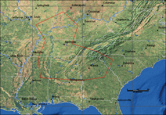
| 111 | USA - South | North America | Tennessee - Chattanooga
area. Columbia. Savannah. Fayetteville. Counties: Lawrence, Warren, Hamilton,
Sequatchie, Grundy. Graysville, Waynesboro area. Rivers: Duck, Elk, Tennessee
river tributaries, Little Pigeon, Chickamauga creek. Alabama - Whitesburg. Counties: Lauderdale, Jackson, Jefferson, Madison. Huntsville, Florence, Woodville, Walker. Rivers: Flint, Cahaba, Five Mile Creek. Georgia - Columbus. West Point. Counties: Troup, Harris, Meriwether, Fulton, Walker, Cobb, . Marietta. Rivers: Chattahoochee, Oostanaula. Lower Ohio River, Wabash River. |
6-May-03 | 13-May-03 | 8 | 3 | 2,000 | $ 17,000,000 | Rain | 42 | 2 | TsuCpSe* | 272,100 | 21.7 | Worst floods in 30 years at
Chattanooga. Chattahoochee River at West Point highest level since at least
1961. Major flooding in Savannah, Tennessee. Central Alabama set a record for rainfall in a two-hour period may 7, with 10 to 11 inches falling near the Birmingham airport. Worst floods in Huntsville since 1990, worst in Jefferson County in 24 years. Cahaba River in Alabama crested at a near-record level May 8. Columbus, Georgia - worst flooding in 13 years. May 8 - After several wet days 6 to 10 inches of rain fell in parts of Tennessee, Alabama and Georgia over 24 hours "biggest spring rains in more than five years and pushed the Tennessee River to some of its highest levels in Chattanooga in three decades" |
|||||||||||||||||||
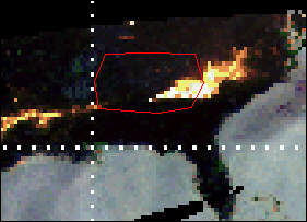
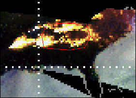
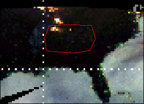
| TRMM data showing frontal storm producing heavy rain over southeastern USA from May 5 - May 7, 2003 | |||||||||||||||||||||||||||||||||||
|
|||||||||||||||||||||||||||||||||||
| 37745 | 5-May-03 | 6-May-03 | |||||||||||||||||||||||||||||||||
|
|||||||||||||||||||||||||||||||||||
| 7-May-03 | 8-May-03 | ||||||||||||||||||||||||||||||||||
| Dartmouth Flood Observatory Homepage | |||||||||||||||||||||||||||||||||||

