| River and Reservoir Watch
Version 4.5 |
|
|
|
|
|
|
|
|
| River
Discharge and Reservoir Storage Changes Using Satellite Microwave Radiometry |
|
|
|
|
|
|
| Uncalibrated
to discharge and actual catchment area |
Great Ruaha |
Center: |
38.97 |
Long. |
Signal/Noise: |
8.1 |
|
| GFDS Area ID: |
1290 |
|
|
Tanzania |
|
Center: |
-8.01 |
Lat. |
|
Good |
|
| GEE Time Series |
|
WorldView
Time Series |
Learn more about
this river |
|
|
21359 |
sq km |
WBM contributing area |
| Last measured: |
30-Dec-24 |
|
|
|
|
|
|
|
|
|
|
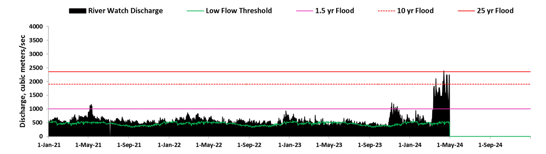
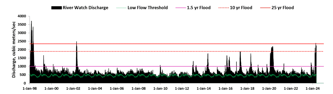
| Discharge: |
|
538 |
m3/sec |
|
Status: |
2 |
(1, low; 2, normal flow; 3, moderate flood, r
>1.5 y; 4, major flood, r >5 y) |
|
| 7-day Runoff |
14.4 |
mm |
|
|
#N/A |
(7-day runoff compared to 20 y average for this
date, 2002-2021) |
|
| Flood Magnitude: |
0.0 |
Scale of 0-10 |
|
Flood
Magnitude Defined |
|
|
Technical
Summary |
|
|
|
|
|
|
|
|
|
|
|
|
|
|
|
|
|
|
|
|
|
|
|
|
|
|
|
|
|
|
|
|
|
|
|
|
|
|
|
|
|
|
|
|
|
|
|
|
|
|
|
|
|
|
|
|
|
|
|
|
|
|
|
|
|
|
|
|
|
|
|
|
|
|
|
|
|
|
|
|
|
|
|
|
|
|
|
|
|
|
|
|
|
|
|
|
|
|
|
|
|
|
|
|
|
|
|
|
|
|
|
|
|
|
|
|
|
|
|
|
|
|
|
|
|
|
|
|
|
|
|
|
|
|
|
|
|
|
|
|
|
|
|
|
|
|
|
|
|
|
|
|
|
|
|
|
|
|
|
|
|
|
|
|
|
|
|
|
|
|
|
|
|
|
|
|
|
|
|
|
|
|
|
|
|
|
|
|
|
|
|
|
|
|
|
|
|
|
|
|
|
|
|
|
|
|
|
|
|
|
|
|
Notes: |
7-day forward weighted moving average is
applied. |
|
Geolocation correction, commencing April 1,
2012: |
0 |
|
|
|
Low flow is 20th percentile discharge for this
day, 2003-2013. |
|
|
|
|
|
|
|
|
|
|
|
|
|
|
|
|
|
|
|
|
|
|
|
|
|
|
|
|
|
|
|
|
|
|
|
|
|
|
|
|
|
|
|
|
|
|
|
|
|
|
|
|
|
|
|
|
|
|
|
|
|
|
|
|
|
|
|
|
|
|
|
|
|
|
|
|
|
|
|
|
|
|
|
|
|
|
|
|
|
|
|
|
|
|
|
|
|
|
|
|
|
|
|
|
|
|
|
|
|
|
|
|
|
|
|
|
|
|
|
|
|
|
|
|
|
|
|
|
|
|
|
|
|
|
|
|
|
|
|
|
|
|
|
|
|
|
|
|
|
|
|
|
|
|
|
|
|
|
|
|
|
|
|
|
|
|
|
|
|
|
|
|
|
|
|
|
|
|
|
|
|
|
|
|
|
|
|
|
|
|
|
|
|
|
|
|
|
|
|
|
|
|
|
|
|
|
|
|
|
|
|
|
|
|
Log
Pearson III computes recurrence intervals from 19 years of record (2002-2019) |
Change in 10 yr flood discharge (2010-2021
/1998-2009): |
198.0% |
|
|
|
|
|
|
|
|
|
|
|
|
|
|
|
|
|
|
|
|
|
|
|
|
|
|
|
|
|
|
|
|
|
|
|
|
|
|
|
|
|
|
|
|
|
|
|
|
|
|
|
|
|
|
|
|
|
|
|
|
|
|
|
|
|
|
|
|
|
|
|
|
|
|
|
|
|
|
|
|
|
|
|
|
|
|
|
|
|
|
|
|
|
|
|
|
|
|
|
|
|
|
|
|
|
|
|
|
|
|
|
|
|
|
|
|
|
|
|
|
|
|
|
|
|
|
|
|
|
|
|
|
|
|
|
|
|
|
|
|
|
|
|
|
|
|
|
|
|
|
|
|
|
|
|
|
|
|
|
|
|
|
|
|
|
|
|
|
|
|
|
|
|
|
|
|
|
|
|
|
|
|
|
|
|
|
|
|
|
|
|
|
|
|
|
|
|
|
|
|
|
|
|
|
|
|
|
|
|
|
|
|
|
|
|
|
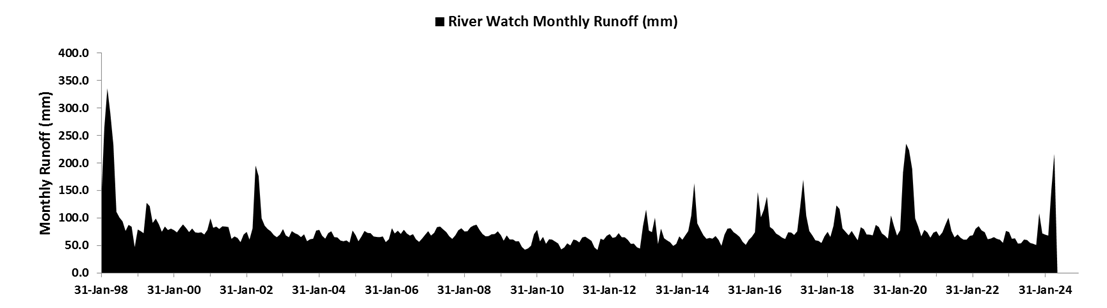
Mean discharge |
639 |
m3/s |
|
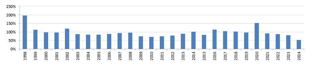
| Annual Runoff (percent of mean, 1998-2021) |
|
|
|
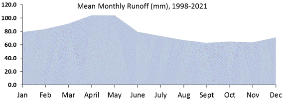
Mean Runoff |
|
948 |
mm |
|
|
|
|
|
|
|
|
|
|
|
|
|
|
|
|
|
|
|
|
|
|
|
|
|
|
|
|
|
|
|
|
|
|
|
|
|
|
|
|
|
|
|
|
|
|
|
|
|
|
|
|
|
|
|
|
|
|
|
|
|
|
|
|
|
|
|
|
|
|
|
|
|
|
|
|
|
|
|
|
|
|
|
|
|
|
|
|
|
|
|
|
|
|
|
|
|
|
|
|
|
|
|
|
|
|
|
|
|
|
|
|
|
|
|
|
|
|
|
|
|
|
|
|
|
|
|
|
|
|
|
|
|
|
|
|
|
|
|
|
|
|
|
|
|
|
|
|
|
|
|
|
|
|
|
|
|
|
|
|
|
|
|
|
|
|
|
|
|
|
|
|
|
|
|
|
|
|
|
|
|
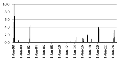
Major
Floods |
|
Change in Annual Runoff (2010-2021/1998-2009): |
94.3% |
|
|
|
|
|
10 = Flood of Record |
|
|
|
|
|
|
|
|
|
|
|
|
|
|
|
|
|
|
|
|
|
|
|
|
|
|
|
|
|
|
|
|
|
|
|
|
|
|
|
|
|
|
|
|
|
|
|
|
|
|
|
|
|
|
|
|
|
|
|
|
|
|
|
|
|
|
|
|
|
|
|
|
|
|
|
|
|
|
|
|
|
|
|
|
|
|
|
|
|
|
|
|
|
|
|
|
|
|
|
|
|
|
|
|
|
|
|
|
|
|
|
|
|
|
|
| Protected Under
United States Copyright Law |
|
|
|
|
|
|
|
Access
to Data |
| Sample
Citation: Brakenridge, G. R., Kettner, A. J., Nghiem, S. V., Kugler, Zs.,
Paris, S. and Cohen, S., River and Reservoir Watch Version 4.5, |
|
|
|
| DFO Flood
Observatory, University of Colorado, USA.
http://floodobservatory.colorado.edu/ SiteDisplays/ 20.htm (Accessed 20
February 2023). |
|
|
| Robert.Brakenridge@Colorado.edu |
|
|
|
|
|
|
|
|
|
|
|
|
|
|
|
|
|
|
|
|
|
|
|
|
|
|
Coefficients of
Polynomial or Linear Rating Curve used: |
|
|
|
-21939.23 |
22034.54 |
|
|
|
|
|
|
|
|
x^4 |
x^3 |
x^2 |
x |
+ |
|
|
|
|
|
|
|
|
|
|
|
|
|
|