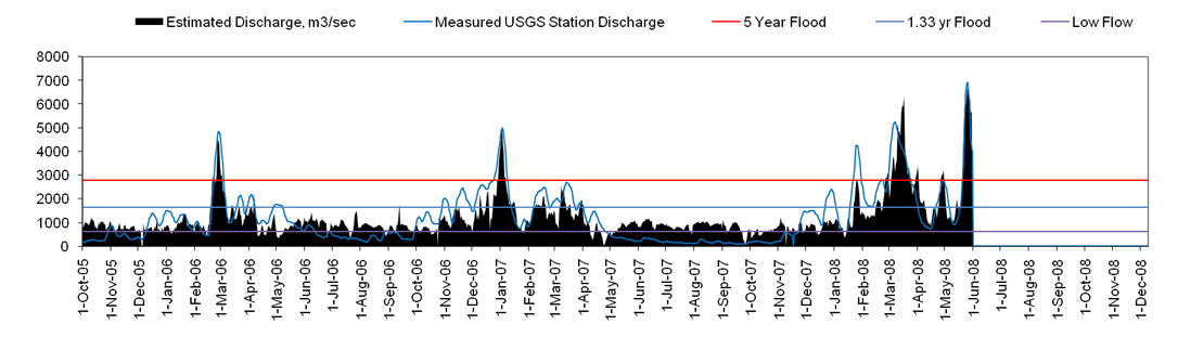
| Samples of AMSR-E/River Watch Output | |||||||||||||||||
| Site ID: | 98 | Lat. | 38.1708 | USA | Indiana | ||||||||||||
| River: | Wabash | Long. | -87.9415 | ||||||||||||||
| Site name: | New Harmony | Contributing area: | 76,112 | km2 | |||||||||||||
| Latest measurement: | 22-Jun-08 | Mean annual runoff: | #DIV/0! | mm | (period of record: 2003-2007) | ||||||||||||
| Hydrologic status: | 4 | Major flood | Total runoff this year: | 0 | mm | ||||||||||||
| Latest M/C ratio: | 1.553 | Seven day total: | 28 | mm | |||||||||||||
| Estimated current discharge: | 3559 | m3/sec | Percent of mean 7-day total: | 136 | % | ||||||||||||
| Ice-cover determination: | Not applicable | Predicted 5 yr recurrence flood: | 2800 | m3/sec | (from Log Pearson III analysis) | ||||||||||||
| Ground Station Information: | GRDC: | Mount Carmel, Ill. (4123130) | |||||||||||||||
| (Monthly and other discharge data from this gaging station are used for the calibration to discharge) | |||||||||||||||||
| Estimated discharge and runoff, based on | |||||||||||||||||
| NASA/JAXA AMSR-E 36.5 GHz microwave emission data | |||||||||||||||||
|
|||||||||||||||||