 |
Detailed Locations:
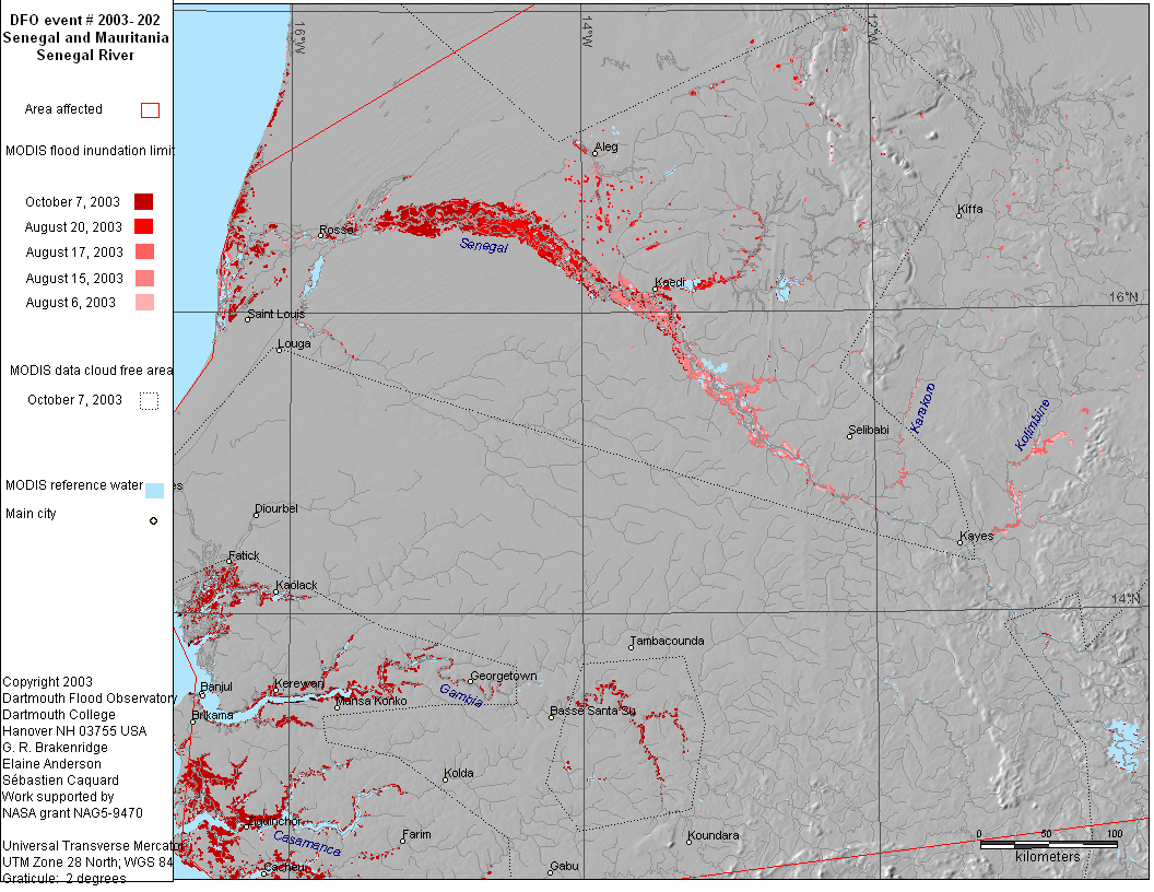
Senegal - Northern Kanel region, Central Nioro region, Matam region.
Kaolack, Kaffrine. Assaba, Gorgol, Brakna and Adrar
Southeastern Mauritania - Affole area, Timbedra
Gambia - Upper River Division
Guinea-Bissau - eastern area. Bafata and Gabu provinces. Geba river
valley.
Rivers:
Senegal River and Tributaries
Gambia River and Tributaries
Guinea-Bissau - Geba river
Comments:
"Exceptional Heavy Rainfall" in the Sahel started in May.
"wettest rainy season in the Sahel for more than 30 years"
Senegal: Torrential rainstorms kill 7. 152 mm of rain in 24 hours
in northern parts of Kanel. Roads were cut by flooding, cattle washed
away, and food stocks lost in many areas. Septmeber 9 - "The
IFRC said the Senegal River was still rising, drowning crops that
were in the early stages of germination"
Mauritania: Almost a full years rainfall in 24 hours, houses destroyed,
markets flooded. 3 killed in Timbedra. Dyke and dam bursts in the
Affole agricultural area.
Gambia: flooding in Upper River division on August 24, September
3 and 17.
Guinea-Bissau: vast areas cropland destroyed in Geba river valley.
MODIS observations of flooding on the Senegal River on August 15,
17, 20, 24, 26, 29, September 2, 9, 14, 16, 25, 28, 30 and October
2, 4, 7, 16, 18.
MODIS observations of high levels on upper Gambia river on Septmeber
19, 23 and October 7.
|