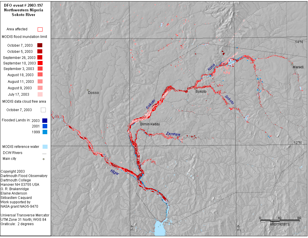
DFO 2003-197

Flooding: 08/05/03 - ongoing (as of 10/12/03)

Northwestern Nigeria - Niger River Basin

Detailed Locations:
Northwestern Nigeria - Sokoto State (Goronyo)
Southern Niger - Dosso, Tahouna, Tillaberi and Zinder regions

Rivers:
Sokoto, Niger

Comments:
No news reports, may be seasonal flooding, although "Exceptional Heavy Rainfall" in the Sahel started in May. Seven dead and 30,000 "affected" in southern Niger by floods in July. News reports of flood damage to crops in Goronyo, Sokoto on September 18.
High levels on the Sokoto River first observed by monitoring MODIS imagery in mid July, and again on August 5; water levels were much higher when first good data obtained on August 9 and 11. Additional MODIS observations of high levels on the Sokoto and Niger rivers on August 9, 18, 19, 27. September 1, 3, 5, 10, 17, 19, 21, 26 and October 3, 5, 7. Flooding receded on the upper Sokoto river first observed on October 3, 5, 7.

Dead: 7 Displaced: 10,000 Damages: no data Affected Region ( sq km): 138,900 Severity Class* : 1 Flood Magnitude**: 15.5 MODIS flood inundation limit file names***:
20032801000USokoto197M2.39
20032781010NigerSokoto197M2.34
20032691315OtiVolta206Ma2.42.49
20032531015NigSoko197M2.40
20032461310NigSoko197Ma2.42
20032461010NigSoko197M2.40
20032301310SokoNig197Ma2.48
20032301010Sokoto197M2.43
20032231305Sokoto197Ma2.43
20032211015Sokoto197M2.38
20031981010Sokoto197M2.39
20031981310NigSokoto197Ma2.45


Map preparation and image analysis: Elaine Anderson

DFO Homepage