Flood Hydroclimatological Analysis
DFO 2000-7
Flooding: 02/09/00-03/07/00
Madgascar
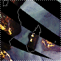
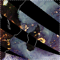
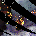
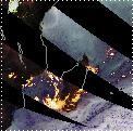
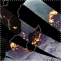
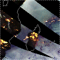
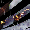
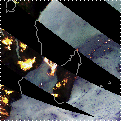
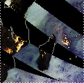
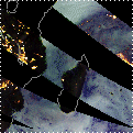
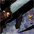
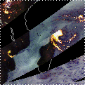
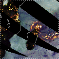
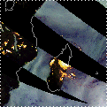
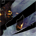
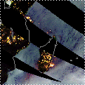
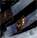
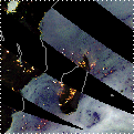
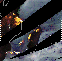
(1) 28 Day Precipitation History
TRMM TMI Quick Look Images, subsetted at Dartmouth
from global mosaics prepared by Chris Kidd, NASA-Goddard Space
Flight Center
Comments:
On February 17, 2000, cyclone Leon-Eline hit
the eastern coast of Madagascar with great strength, crossing
the island around 80 km north of Antananarivo (US Agency for International
Development (USAID) / Office of US Foreign Disaster Assistance
(OFDA) Regional Advisor Report #15). TRMM TMI images below show
cyclone Leon-Eline appearing off the east coast of the island
as early as February 14. Although rain continued over the island
for a week, the body of the storm passed over Madagascar in a
couple of days and moved on towards mainland Africa. Less than
a week after the rain had subsided, tropical storm Gloria pounded
Madagascar, following a similar path as cyclone Eline across the
country (USAID/OFDA Regional Advisor Report #15). TRMM TMI images
show Gloria approaching the northeastern coast of Madagascar on
February 28, holding position over the northernmost tip of the
country during February 29-March 1, and covering the island with
heavy precipitation from March 2-5. Madagascar, which sits off
the southeast coast of mainland Africa experiences the full brunt
of storms as they come off the Indian Ocean.
Heavy rain associated with cyclone Leon-Eline
and tropical storm Gloria resulted in widespread flooding on across
the island "including the western side, which is usually
protected by inland mountains and is unaccustomed to storm damage
and serious flooding" (Dr Sergio Soro, Unicef's representative
in Madagascar's capital Antananarivo as cited in PR Newswire Europe
Limited Press Association Newsfile, March 9, 2000). Adventist
Development and Relief Agency reported 75,000 people were stranded
by landslides. Flooding, heaviest in the districts of Vatomandry,Mahanoro,
Antanambao Manampotsy, Anosibe an'Ala, Marolambo, and Belo-Tsiribihina
(M2 Communications Ltd. M2 PRESSWIRE, March 6, 2000) left some
200 people dead and around 22,158 displaced (Government of Madagascar
National Disaster Unit). As of March 27, around 130,000 people
were still displaced, isolated and/or were in need of immediate
assistance (U.N World Food Program).
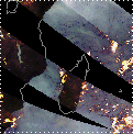
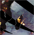
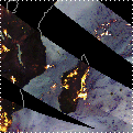
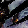
In these images:
Rainfall and snowfall: yellow and white areas
(yellowish white is highest intensity precipitation)
Oceans: light blue (low water vapour) to dark
blue (high water vapour)
More information: http://trmm.gsfc.nasa.gov/data/quicklook/quick_looks.html
| 02/09/00 |
02/10/00 |
02/11/00 |
02/12/00 |
02/13/00 |
02/14/00 |
02/15/00 |
 |
 |
 |
 |
 |
 |
 |
| 02/16/00 |
02/17/00 |
02/18/00 |
02/19/00 |
02/20/00 |
02/21/00 |
02/22/00 |
 |
 |
 |
 |
 |
 |
 |
| 02/23/00 |
02/24/00 |
02/25/00 |
02/26/00 |
02/27/00 |
02/28/00 |
02/29/00 |
 |
 |
 |
 |
 |
 |
 |
| 03/01/00 |
03/02/00 |
03/03/00 |
03/04/00 |
03/05/00 |
03/06/00 |
03/07/00 |
 |
 |
 |
 |
 |
 |
 |
DFO Homepage